
Chase Forecast No. 1 ~ 2025-03-05
Hello Everyone!
Starting something new this season where I write out my storm chasing forecasts in order to both help myself organize my thoughts and provide insight into my process for selecting storm chasing targets. This will be my first chase of the season so I’m very much looking to shake off the rust and this seems like a great opportunity to get the wheels greased back up! This may not be the only discussion on this event, I might publish another one late tonight if there is a significant shift in my idea (we’ll see).

Let’s start with the current big picture. A deepening surface low associated with an ejecting upper level trough is progressing eastward from the Central Great Plains into the Midwest. Today (Tuesday the 4th) has been considered to be the ‘main day’ of this system for a week now as severe gusts and multiple tornadoes are expected across the deep south. Numerous tornadoes have already occurred overnight in Quasi-Linear Convective System (QLCS) segments. This system will progress northeast overnight, dragging the charged Gulf environment with it into the Carolinas and Mid-Atlantic tomorrow.
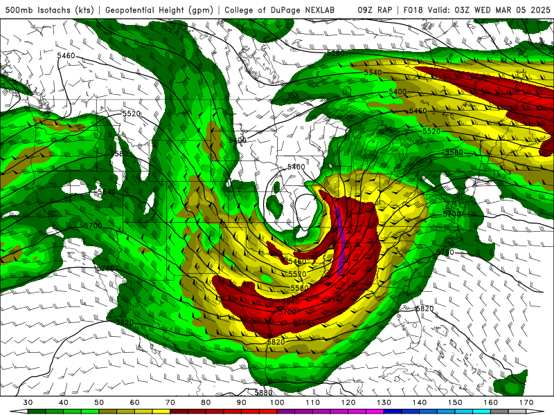
Starting in the upper levels going into tomorrow, we can see the deepening closed low traversing the Midwest to the northeast. The associated trough will eject over the Mid-Atlantic and into the Northeastern United States. The jet will be maximized over North Carolina and Virginia with greater than 100 kt flow at 500 mb. I believe early spring kinematics will be very important to make up for the lack of other ingredients near the surface. It is also worth noting that this trough is slightly negative to neutral throughout its progression eastward. While I would like to see a more negative tilt, I think the upper level kinematics are more than sufficient to get the job done, and some ways may prove to be a bit of an issue in terms of storm motions. Getting further lower into the atmosphere, widespread 55+ kt flow across tomorrow’s focus area at 850 mb in a primarily southerly orientation. Gulf air is being funneled north, with above-freezing temps making it as far north as the Canadian border at this height of 850 mb.


At the surface, I’m starting with Moisture, as that is usually what is of most concern for these early season setups. This powerful low however has brought up a great deal of moisture for this early in the season. While it is obvious the Carolinas will see the best deal of moisture, what most catches my attention is this projected pocket of moisture working its way up the Ohio River Valley. While mid 50 dew points seems concerning, popping over to temperatures, our high heading into that same region is at best mid 60s. With a temperature/dew point spread like that, that’ll put cloud bases at a healthy height for tornado producing.
Diving into some of the thermodynamic products, that is where I believe the story gets better for that general vicinity of Western PA. MLCAPE is rather yucky across the region, with it once again being maximized over northern Ohio River Valley. However, in the lowest levels (0-3 km), we have a bullseye for that lowest layer of CAPE, the instability most needed for tornadogenesis. Even our mid-level lapse rates make an appearance, getting up to 7 C/km, which isn’t great, but coupled with them nearing 8 C/km in the low levels should be enough to make things happen for isolated storms. Lid Strength could be a problem, with instances further north reaching 3 C, but further south into the Ohio River Valley is sticking around 1 C, which I believe to be the goldilocks zone for keeping storms isolated. I’ve found in the Northeastern US, once you are a 0 C or negative, upscale development is nearly guaranteed.


So ultimately, what is it about this Western PA target that makes it more appealing than the Carolinas into Virginia, where the SPC has their 5% tornado risk contour? Well, that 5% is being held for the early convective line. The actual primary threat for the day is that main line of storms that’ll move through in the morning time. What we’ll be targeting as the chasable threat that will form behind the morning rain. The convective line through the Carolinas and into the Mid-Atlantic will use up all of the juice of the atmosphere such that nothing in the following dry slot will be able to initiate. Further north, however, that environment surging northward will have time to mature throughout the day so once cloud cover clears away, that’ll be the heating kick needed to fire storms off. Little embedded shortwaves in the upper levels will also assist in creating the ascent needed to develop severe storms. Today’s 12Z HRRR run has indicated that this is a likely case, which makes sense given the environmental evolution.

Looking at a RAP sounding in our Western PA target, a couple of things are worth noting. The hodograph has storm motion at NNE at 45 kts. In the Northeast, this will be problematic and will require timed intercepts ahead of the storm. Keeping up with these storms is unlikely, however, the hodograph tells me that precipitation should be shoved out of the way of the updraft base, so we should be working with rather visible tornadoes if they do form. While thermos are rather underwhelming, I believe it is where it needs to be to support tornadogenesis with the strongest cell.
As of now, Western PA will be my target for tomorrow’s chase. I’ll dial in a specific area early tomorrow morning and will tweet out updates from my personal account. If anything major changes between now and tomorrow morning, I’ll likely upload another forecast discussion. A video version of my thoughts relating to this setup will be uploaded for June First Patreon supporters (Supercell and up Tiers). Cannot wait to get my 2025 chase season underway!
Cheers,
Ethan